
Antarctic Peaks Spark Lost Civilization Theories Amidst Striking Resemblance to Giza Pyramids
A series of ice-covered peaks in Antarctica, bearing a remarkable resemblance to the famed pyramids of Giza, Egypt, has ignited a fervent debate and fueled theories of a long-lost global civilization. Independent researcher Jay Anderson first brought attention to these formations by overlaying Google Earth imagery of the Antarctic structures with satellite photos of the Giza pyramids, highlighting their uncanny alignment.
Located in the southern part of the Ellsworth Mountains, one of Antarctica’s most formidable and rugged mountain ranges, these formations are situated at coordinates 79°58’39.0″S 81°57’34.0″W on Google Earth. The striking visual parallels have sent ripples across the internet, prompting widespread speculation about their origin: are they the product of natural geological processes, or the remnants of an advanced, ancient human civilization?
Echoes of a Bygone Era?
The notion of a lost civilization predating current historical records has captured the imagination of many. Online discussions have seen a surge of theories suggesting that if these formations are indeed artificial, they would provide definitive evidence of “crust displacement” – a concept positing that the Earth’s surface has shifted significantly throughout history. Proponents of this idea believe such a discovery would conclusively prove the existence of a highly sophisticated civilization that flourished long before any known ancient societies.
The Geological Perspective: Erosion as the Sculptor
However, the scientific community largely attributes these pyramid-like shapes to the slow, persistent work of natural erosion. Geologists explain that the characteristic sharp angles and tiered appearance of these mountains are likely the result of hundreds of millions of years of geological processes, particularly freeze-thaw erosion. This phenomenon occurs when water, often from melting snow, seeps into existing cracks and fissures in the rock. As temperatures plummet, this water freezes, expands, and exerts immense pressure, gradually widening the cracks. Over vast timescales, this cycle of freezing and thawing can break off substantial portions of rock, shaping the surrounding landscape into dramatic forms, including those that mimic geometric structures.
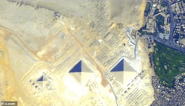
The central Antarctic formation stands approximately 4,500 feet tall and features four distinct, steep sides. It appears to be flanked by two smaller, similarly shaped peaks, all emerging from the vast expanse of snow and ice. This arrangement has been compared to the Giza plateau, which hosts the three principal pyramids: Khufu, Khafre, and Menkaure. These Egyptian monuments are arranged in a diagonal line, an alignment that some have controversially linked to the stars of Orion’s Belt. The perceived mirroring of this alignment by the Antarctic peaks has further fueled speculation.
Despite the intriguing visual correlations, experts like Eric Rignot, a professor of Earth system science at the University of California, Irvine, and a senior research scientist at NASA, have previously stated that such formations are simply mountains that coincidentally resemble pyramids. He emphasizes that the steep slopes are a natural consequence of geological forces and weathering, honed over eons.
Mauri Pelto, a professor of environmental science at Nichols College in Dudley, Massachusetts, concurs, noting that freeze-thaw erosion is a common mechanism responsible for shaping many prominent pyramidal mountains worldwide, including iconic structures like the Matterhorn in the Swiss Alps.
From Conspiracy to Nunataks: A Shifting Narrative
The pyramid-shaped mountain in Antarctica, which lacks an official designation, first captured widespread internet attention in 2016. At that time, it became the subject of alien conspiracy theories, with some suggesting it was a hidden extraterrestrial base. These claims gained traction following the release of a video by the YouTube channel “Third Phase of the Moon,” known for its content on alien phenomena. The video showcased a pyramid-like structure captured via Google Earth, complete with a label that read “Antartica Pyramid” – a misspelling that some noted as a potential indicator of digital manipulation.
Reactions to the video were polarized. While some viewers expressed belief in the extraordinary claims, citing a sense of impending dramatic global events, others were quick to dismiss them. Skeptics, drawing from personal experience with mountainous terrains, argued that the formations appeared entirely natural and man-made structures were highly improbable.
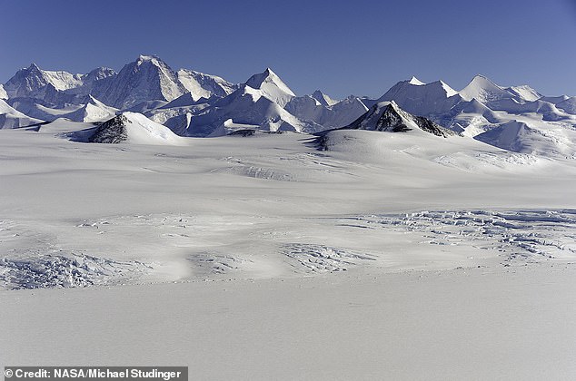
Geologists and other experts have offered a more grounded explanation: the structures are likely “nunataks.” A nunatak is a natural mountain peak or ridge that protrudes above the surrounding ice or glaciers, often remaining exposed due to its height and the erosive forces that have shaped the wider landscape.
Nigel Watson, author of the “UFO Investigations Manual,” commented on the phenomenon in 2016, suggesting that images of these supposed pyramids were either digitally altered, selectively cropped to enhance their resemblance to man-made structures, or simply photographs of natural geological formations like nunataks. He asserted that these formations are the result of glacial movement and erosion, not extraterrestrial intervention. The debate, however, continues to highlight humanity’s enduring fascination with the unknown and the mysteries that the Earth’s most remote corners may still hold.


